Driving Tour of the Pryors
without 4WD
Pryor Mountain Road and Crooked Creek Road
Big Pryor Mountain and the Crooked Creek Junction area from the road to Big Ice Cave.
Crooked Creek Rd on the left and a bit of Pryor Mountain Rd and the junction on the far right.
(Unless cropped by the small screen of a smartphone.)
d. walton photo
Pryor Mountain Road (PMR) is the primary motorized access into the north Pryor Mountains. It is a scenic drive providing great views, opportunities for bird and wildflower watching, and a drive back through 400 million years of geologic history. (See geologic road log.) Sage Creek Campground and Big Ice Cave picnic area are the only developed areas. The Crater Ice Cave / Big Pryor Mountain Trail begins from Tie Flat just off this road. The Roberts Bench Hike begins near Crooked Creek Junction. The Cave Ridge hike begins from the Big Ice Cave picnic area. (See Trail Guides for these hikes.)
Pryor Mountain Road is not well signed, but these directions should help first time visitors. It is called, and signed, route #2308 within USFS managed land.
Pryor Mountain Road is NOT an all weather road. The majority of the road is good gravel, but some sections are rough and rocky, or muddy when wet. When it is dry some standard highway vehicles can make it - if driven carefully, but higher clearance vehicles like most SUVs are preferable. Four wheel drive is not needed in dry conditions. But when it is wet there are sections which are often impassable even with 4WD.
PMR can provide and in and back out tour of the north Pryors, or with Crooked Creek Road can provide a loop route through the north and south Pryors.
See an excellent blog about the loop drive by Joy Carlough - with great photos: Ride~About: Montana’s Unique Pryor Mountains (It does not include the optional side-trip to Big Ice Cave and Dryhead Vista.)
Download a printable pdfs of these Pryors Driving Tour Directions and Driving Tour Maps keyed to the directions.

Overview Map (Click maps to enlarge)

Big Pryor Mountain details
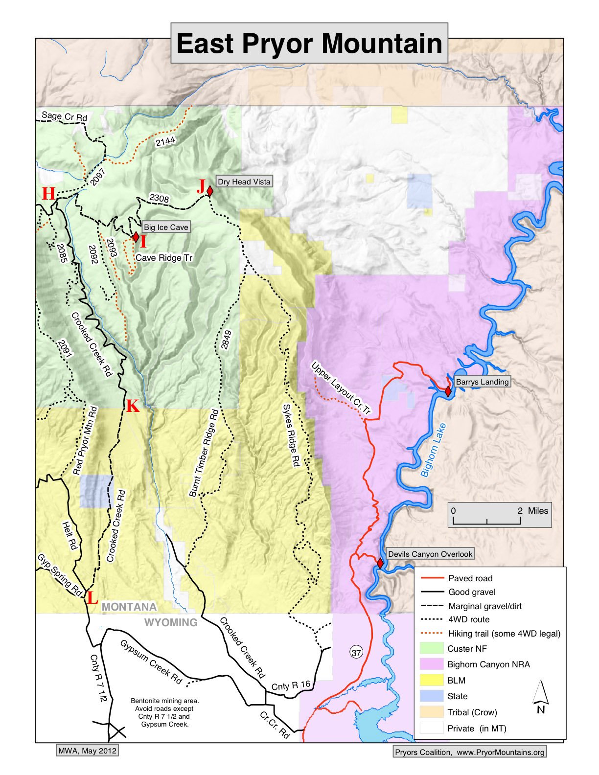
East Pryor Mountain Details
A. Pryor Mountain Road turns east from Highway 310.
Driving Tour Directions:
Take Hghway 310 south from Bridger MT. Pryor Mountain Road turns left (east) 2.5 miles south of Bridger and 0.5 mile south of the bridge over the Clarks Fork of the Yellowstone River. (This junction is 1.4 miles south of the junction of Highways 310 and 72 from Belfry and Red Lodge.). Turn just north of the house on the east side of the highway.
All mileages below are measured from the beginning of Pryor Mountain Road. Note that odometer readings vary among different vehicles. Also road signs sometimes disappear, appear or change.
Each lettered point below is marked on the maps above.
A. 0.0 miles: Pryor Mountain Road. Turn east on Pryor Mountain Road. Just after the turn, on the right, a sign says “National Forest Boundary 24, Big Ice Cave 36.” The road is paved for 2.0 miles to where it crosses a railroad track. The road has a good gravel surface for the next 13 miles.
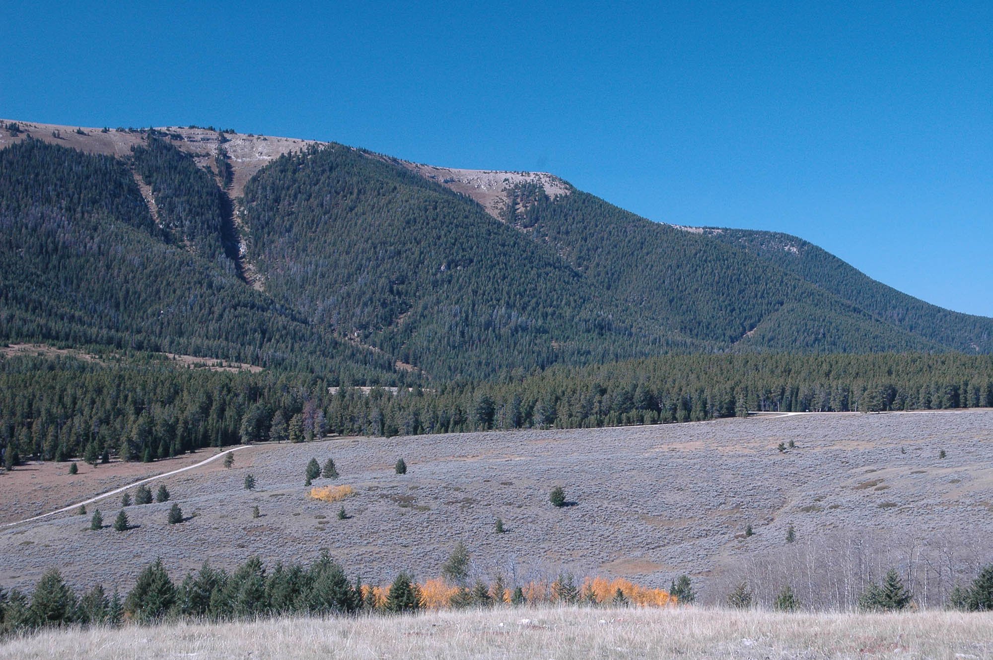
B. 9.5 miles: Bowler Flat. The road climbs to Bowler Flat and a big view of Big Pryor Mountain. There is now a big wind farm with more than 100 large turbines on Bowler Flat.

B. Bowler Flat & Big Pryor Mountain - before the wind farm. (d. walton photos)

C. Transformers south of PMR just west of Bowler Junction.

C. Bowler Junction. PMR turns left (north).
C. 12.2 miles: Bowler Junction. Turn left (north). There may be no sign at this junction. There are several power poles and transformers inside a chain link fence on the right (south) just before the junction. Nothing is left of the old Bowler Post Office which used to be there. Remember to turn right at this junction on the return trip. From this junction Pryor Mountain Road follows section lines for a mile north, then a mile east, another mile north then turns east again.
15.0 miles: Enter Crow Indian Reservation. Sometimes there is a sign. Avoid trespassing off the road. The gravel road surface deteriorates between here and the old railroad crossing, but is usually OK
D. PMR crosses Railbed Rd.
D. 16.5 miles: Old railroad crossing. Go straight across the four way junction. (It is actually a 45 degree left turn, but do not turn 90 degrees onto Railbed Road.) The old railroad through Pryor Gap is long gone and replaced with a road. There probably is no road sign, but the raised railroad bed is obvious. After this crossing the road surface is more dirt than gravel. The five miles from here to the Forest boundary can be very muddy when wet, and impassible even with a 4WD.
E. 21.5 miles: Junction. Take right fork. Left fork has large blue sign: “No Trespassing: Crow Tribal Members Only”
F. 22.0 miles: National Forest Boundary. Cattle guard. The next eight miles is good gravel road.
G. 22.6 miles: Junction. Follow Pryor Mountain Road straight ahead. Left turn goes to Sage Creek Campground in about a half mile.
… 29.7 miles: Route #2104 turns right to Tie Flat and the Crater Ice Cave / Big Pryor Mountain Trail.
H. Crooked Creek Junction.
H. GE view of Crooked Creek Junction.
H. 30.3 miles: Crooked Creek Junction.
At this junction there are two alternatives:
1. Continue on PMR for 4 miles to Big Ice Cave, and possibly an additional 4 miles to Dry Head Vista - with appropriate vehicle.
2. Turn south on Crooked Creek Rd for the loop drive.
This is actually a double junction. See photo and Google Earth view. First Crooked Creek Road (#2085) turns right. A couple hundred feet later the right fork is Pryor Mountain Rd (#2308) toward Big Ice Cave and Dry Head Vista. (The left fork is #2097, 4WD recommended.)
The Roberts Bench Hike begins near Crooked Creek Junction.
Alternative 1: Big Ice Cave and Dry Head Vista
The good gravel road surface ends at Crooked Creek Junction. The next four miles to Big Ice Cave includes some rough and rocky sections. Careful driving is required. 4WD is not needed when the road is dry. Custer Gallatin National Forest regulations do not permit motorized use past Crooked Creek Junction until late May. There may be no sign; It is your responsibility to know. Get the Motor Vehicle Use Map (MVUM) at the Custer National Forest Office in Billings or Red Lodge.

I. Big Ice Cave: Right. Dry Head Vista: Left.
I. Sign at Big Ice Cave. Click to enlarge.
I. 34.4 miles: Big Ice Cave Junction.
Go straight ahead a couple hundred yards to Big Ice Cave, the picnic area, and the Cave Ridge hike.
The left turn goes about four more miles to Dry Head Vista. The rocky road has become much more challenging without high clearance vehicles.
We recommend against attempting it with “ordinary”, low clearance highway vehicles. 4WD is not needed when dry. This road climbs to nearly 8800 ft elevation. Snow and mud can make it impassible even after the late May opening. Do not drive off road to go around snow drifts or mud holes. Turn around and come back another day.
J. 38.7 miles: Dry Head Vista. The several hundred yard spur to Dry Head Vista is closed to motor vehicles to allow recovery of the fragile vegetation, and to respect an area important to Native Americans. The short and easy walk to the Vista is grandly rewarded with panoramic views of the Montana plains to the north and east, and down into the Punch Bowl Creek and Dryhead Creek drainages.
The road beyond Dry Head Vista is not recommended without high clearance 4WD vehicles. When dry 4WD is not needed for several miles, but beyond that the roads become extremely rough and challenging.
Crooked Creek Canyon. (Grant Barnard photo)
IAlternative 2: Crooked Creek Road and the Loop Tour
Crooked Creek Rd connects with gravel roads back to Highway 310 at Warren MT or Cowley WY. There are views of the spectacular Crooked Creek Canyon. Get out and walk a short way for better views or a picnic.
From H. Crooked Creek Junction turn right (south) on Crooked Creek Rd (#2085). The first 9 miles to the south boundary of Custer Gallatin National Forest is good gravel road. It is not passable in the winter. Snow is late melting from this sheltered canyon road. After the 9 miles of Forest Service road, the next 6 miles of BLM road is rougher and rocky in places. It is passable with most highway vehicles if driven very carefully. A high clearance vehicle is better, but 4WD is not necessary when the road is dry.
The mileages given below are measured from the Crooked Creek Junction.
H. 0.0 miles: North end of Crooked Creek Road (#2085) at junction with Pryor Mountain Road.
K. 9.2 miles: Leave Custer National Forest at cattle guard and fence.. Enter Bureau of Land Management area. The road becomes rougher and sometimes rocky for about 6 miles.
Vermillion Valley View.
… 14.8 miles: Vermillion Valley Viewpoint: 5.6 miles south of the USFS/BLM boundary fence and cattleguard (0.6 miles before Helt Rd Junction) the road climbs out of a valley. Stop, turn around, and look back north from the Vermillion Valley Viewpoint. See the geologic story of this view.
L. 15.4 miles: Helt Road Junction & 15.6 miles: Gyp Springs Road Junction
There may not be road signs. These two road junctions are only 0.2 miles apart. Both are right turns to the west from Crooked Creek Rd. Both roads lead back to Highway 310 at Warren MT. The Helt Rd route is about 2 miles longer (16.4 miles vs. 14.3 miles to Warren), and the first part is somewhat rougher (but no worse than the BLM part of Crooked Creek Rd). Helt Rd is more scenic, skirting the southern edge of the Pryors. About 7 miles from Crooked Creek Rd, Gyp Springs Rd ends at a “Y” junction with Helt Rd at point M on the map.
At point N on the map Helt Rd intersects paved Quarry Rd which continues to Warren MT on Highway 310.
Alternatively it is about 10 miles to Cowley WY on Highway 310. from the Helt and Gyp Springs Junctions. Continue on Crooked Creek Road (not on either Helt or Gyp Springs Rd). After about 1.7 miles, a sharp left turn, and crossing a deep gulley is a “T” junction.
“T” Junction. Turn right on County Rd. 7 ½ (the left turn is onto Gypsum Creek Rd.). Continue mostly south ignoring several prominent bentonite mining roads to the left and right.. (Some of these junctions may have no road signs.) 5.4 miles south of the “T” junction, County Rd. 7 ½ changes from dirt/gravel to pavement as the road from the county airport joins from the left (east). It is 2.7 miles of paved road from the airport junction to Cowley Wyoming and Highway 310.