Lisbon Zig-Zag Trail

Beginning of Zig-Zag Trail

Greater Shorthorned Lizard, Phrynosoma hernandes

"The Elephant"

Bernie on the ZZ Trail. (Dick Walton Photos)

View of Demijohn Flat and East Pryor Mountain
Green letters identify Junctions described below.
Lisbon Zig-Zag Trail
The Zig-Zag Trail is a five mile loop hike with outstanding scenery including views of Demijohn Flat, Crooked Creek Canyon with numerous rugged tributary canyons on East Pryor Mountain. There are also striking views of the red beds of Vermillion Valley below. The Zig-Zag trailhead is accessible on Crooked Creek Road with most highway vehicles if driven carefully. Total elevation gain is about 1,500 feet. BLM has not officially designated, signed or mapped the trail for public use, however the 2021 BLM Travel Plan explicitly allows public foot travel (human and/or horse) in the area. The Zig-Zag Trail follows abandoned mining “roads,” but motorized and mechanized (i.e. mountain bike) use is not permitted. Except ....
…. A 1.6 mile segment of the hike follows the Dandy Mine Road which is designated for “limited width” motor vehicles. That would be mostly ATVs. This 1.6 mile segment can be bypassed on foot with an optional 1⁄2 mile off-trail shortcut.
☢️ Alert:
There are numerous abandoned uranium mines in this part of the Pryors which are potential
health and safety hazards. The Zig-Zag loop, as described, only passes one of these mine entrances. (Most of the abandoned mines are west and southwest of the Zig-Zag Trail - not along it.) Hikers who wander off-trail, or on several other abandoned mining tracks in the area, should understand and avoid the hazards. Abandoned mines are notoriously unstable and very dangerous to enter. Just don’t! Most of the mine entrances (including the one by the Zig-Zag Trail) have bat-friendly closures that prevent human entrance. Uranium mines also have hazardous levels of radioactive dust and radon gas. Mine tailings and waste piles near the mines may also be radioactive. They are not a wise place to have lunch or a nap. Don’t spend much time poking around the mines, and don’t take rock samples home.
Unfortunately BLM is seriously considering designating this area as part of a mountain bike and electric bike (e-bike) play area. In the 2020 draft Travel Plan BLM proposed a play area with a maze of 15 miles or more of designated bike routes. They deferred this designation in the final 2021 Travel Plan but clearly suggest it as a future possibility. There are abundant opportunities for mountain biking in the Pryors - some 115 miles on BLM Managed land (and more than 100 miles more on USFS managed land). BLM designates only 11 miles of wheel-free foot-trails in the 2021 Travel Plan. We hope BLM will have the wisdom to designate the Zig-Zag Trail (and other routes) for “non-mechanized” hiking use to provide an opportunity for public wheel-free recreation in the Pryors.
Getting There: Driving Directions
Detailed Maps and Driving Directions to Pryor Mountain hiking trailheads are available on the Hiking Overview page.
Brief Directions (for people familiar with Crooked Creek Road)
The unsigned Zig-Zag Trailhead is on the west side of Crooked Creek Road 0.8 miles south of the USFS/BLM boundary fence and cattleguard, and 5.4 miles north of the junction of Crooked Creek Road and Helt Road. (It is 2.5 miles north of the Penney Trailhead.). Look for jackleg barrier. (See photo below.)
Complete Directions from Highway 310
See Pryor Mountain Map Set at: https://www.pryormountains.org/welcome-to-the-pryors/maps/
When dry the gravel road (via Gyp Springs Rd.) is passable with most highway vehicles to point E below. The final few miles to the trailhead are rougher, but when dry can be driven with many highway vehicles if driven carefully. This depends somewhat on when BLM last graded the road. Do not try it without 4WD when wet or snowy. The drive from Billings to the Zig-Zag Trailhead takes a little over 2 hours.
Drive to Warren MT, 21 miles south of Bridger, on Highway 310. Look for the Montana Limestone Company sign. Warren is where limestone from the quarry at the southwest corner of Big Pryor Mountain is loaded onto railroad cars. There is no “town” at Warren.
A. 0.0 miles: Warren MT. Turn east on Helt road (also called Quarry Rd.). If you are traveling south on Highway 310 it is a left turn. Follow this paved road for 2.7 miles to a junction and road sign. The BLM sign on the right fork says, “Stockman Trail 1.5” and “Bear Canyon Road 3.5”. (The paved road continues left as Quarry Rd.)
B. 2.7 miles: Helt Rd. – Quarry Rd. Junction. Turn right to continue 4.4 miles on Helt Rd. which is now narrower and gravel. Go past BLM signs for Graham Trail, Stockman Trail and Bear Canyon Rd.
C. 7.1 miles: A “Y” in the road and cattle guard. Take the right fork which is Gyp Springs Rd. Continue on Gyp Springs Rd. for 7.0 miles. (The left fork is Helt Rd., a 2 mile longer and somewhat rougher, but more scenic alternate route.)
D. 14.1 miles: Gyp Springs Rd. - Crooked Creek Rd. Junction. Turn left (north) on Crooked Creek Rd.
E. 14.3 miles: Crooked Creek Rd. - Helt Rd. Junction. This is the junction of Helt Rd. (left fork) and Crooked Creek Rd. (right fork). (This is where the longer alternate route from the “Y” at point C above rejoins the route.)
Continue north on Crooked Creek Rd. for 5.4 miles north from the Helt Rd. junction to the unmarked Zig-Zag Trailhead. The last few miles may be rougher. If it is wet or snowy, do not try it without 4WD. If dry it is passable with many highway vehicles driven carefully.
F. 19.7 miles: Unmarked Zig-Zag Trailhead on the left (west) side of Crooked Creek Road. Assuming the loop is hiked in a counterclockwise direction (as described below), the trailhead is the middle of three jackleg barricades. The barricade for the hike return is about 100 feet south of the trailhead. A another barricade about 250 yards to the north. The purpose of the barricades is to prevent unauthorized motorized travel on old two-tracks.(Also see Demijohn Flat, Penney Peak area hikes. The Zig-Zag Trailhead is 2.5 miles north of the Penney Trailhead, and 0.8 miles south of the Demijohn Trailhead.)

Lisbon Zig-Zag Trailhead. Looking Northwest.

Zig-Zag return trail about 100 feet south of Trailhead. Looking Southwest.
Lisbon Zig-Zag Trail
The Zig-Zag Trail follows old two-tracks which are clear and easy to follow - partly due to continued illegal motor vehicle use. Since BLM has not officially designated and signed the route detailed descriptions and photos are may help identify several important junctions. From the Zig-Zag trailhead the trail heads uphill mostly northwest.
Junction A
Junction B
Junction A: (See Junction A photo.) At about 0.6 miles an obvious track forks right (north), crosses a small drainage, and turns back southeast to Crooked Creek Road. This is a thin yellow line on the Google Earth map above. That is not the route. The Zig-Zag Trail continues straight NW. As the hillside steepens the trail soon begins to switchback.
Junction B: (See Junction B photo.) The second important junction is at the sixth sharp right switchback turn. The Zig-Zag Trail leaves the switchbacks at that point contouring south around the hillside at the base of interesting cliffs.
It is 1.4 miles and about 1,200 feet elevation gain to this junction where the Zig-Zag route turns toward the south.
The final switchback (thin yellow line on Google Earth map) heads NW up to the top, the Lisbon mine and beyond. That is not the route for this loop hike.
Junction C: (See two Junction C photos.) The third important junction is 0.6 miles south (including meanders) from the switchbacks (2 miles from the trailhead). The most obvious trail curves right around the hill and doubles back toward the north contour around a drainage. That is not the Zig-Zag route.
The less clear (in August 2021) route turns sharply left, downhill and past several large boulders.
After passing the boulders look back to see a mine entrance (adit) that could not be seen from above. The boulders were apparently placed to prevent anyone from driving off the edge. The adit is closed to prevent human entry. This is the only mine adit along the Zig-Zag Trail.
The GPS coordinates of the mine adit are: 45.074043°N, 108.426383°W
Past the mine adit the trail becomes obvious again continuing south.

Junction C: Mine adit is out of sight beyond boulders.

Looking back past mine adit to Junction C.
Upper Dandy Junction D: The fourth junction is 0.4 miles past the mine. At that point the Zig-Zag Trail intersects the motor-legal (ATVs) Dandy Mine Road in a “T” junction. (See Junction D photo.)
One option is to turn left and follow the Dandy Mine Road switchbacking and winding 1.6 miles down to where the Zig-Zag Return Trail leaves it at Junction E. (Turning right on the Dandy Mine Trail enters the area with the most dense mining activity including several Dandy mine adits.)
The Dandy Mine Road doesn’t have as much traffic as the Crooked Creek Road. But it might have more motorized commotion on weekends than some hikers would prefer. There is an alternative.
The off-trail shortcut shown on the Google Earth map bypasses the Dandy Mine Road. The shortcut descends 600 feet in elevation in ½ mile from Junction D to Junction E. Most of that descent is in the steep middle third of the shortcut.

Upper Dandy Junction D
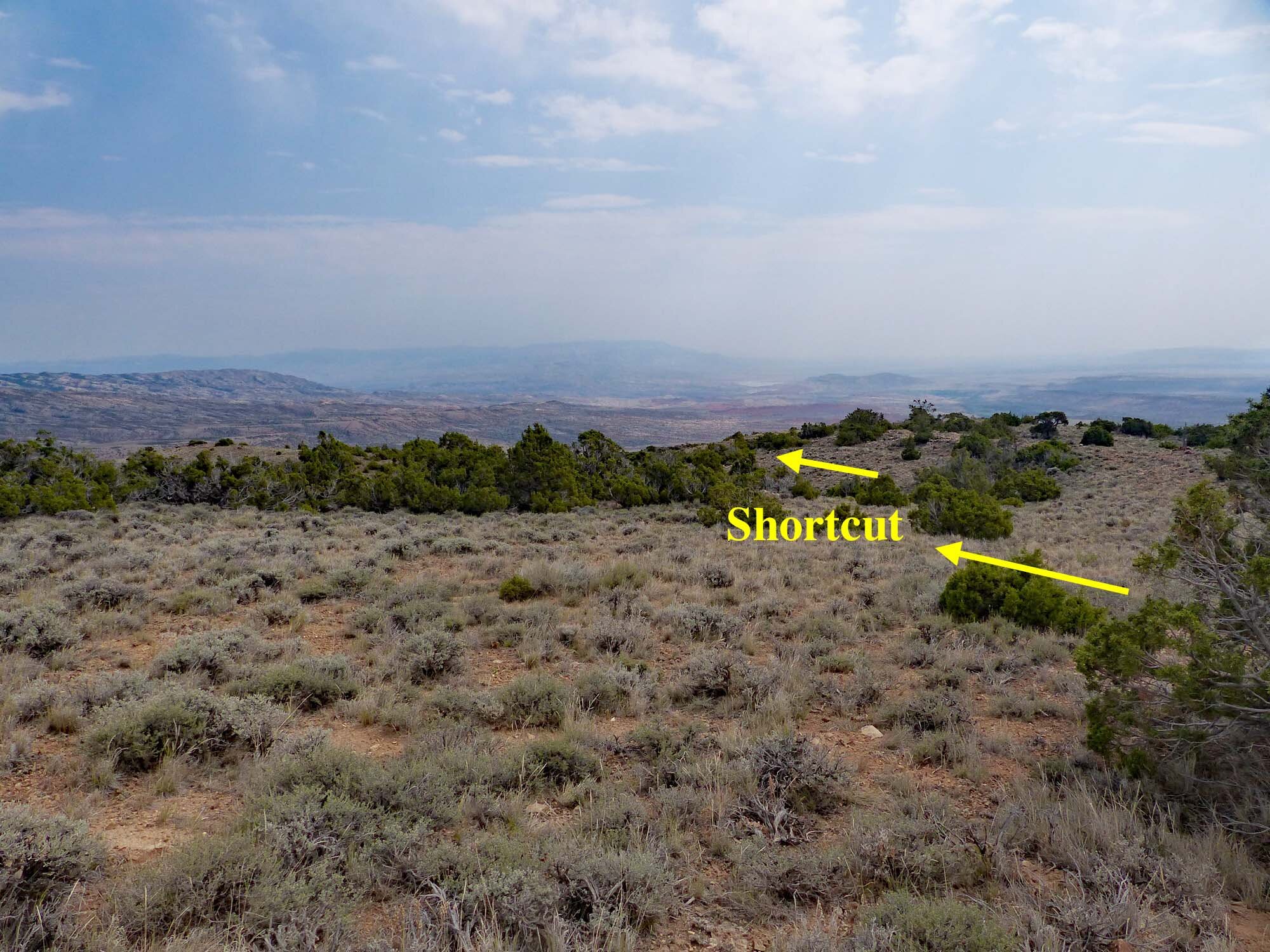
Beginning of shortcut as seen from near Junction D
From the Upper Dandy Mine Junction D, head about 20° south of east. This is approximately perpendicular to the direction of the Zig-Zag Trail as it enters the “T” junction. (See photos.). The precise direction is not critical.
The shortcut requires winding through scrub juniper and other brush. Much of the way the rough and rocky ground slows walking - especially on the steepest midsection, but no rock scrambling is required. Less than half way down, soon after starting the steepest section, the view ahead opens showing the Lower Dandy Junction E where the Zig-Zag Return Trail leaves the Dandy Mine Road. (See photo below.) Head for that junction.

View from midway down shortcut showing Lower Dandy Junction E and return trail. The return trail is visible in the photo just beyond the three yellow arrows. It is obvious on the ground.

Lower Dandy Junction E and Zig-Zag Return Trail
From junction E follow the Return Trail 0.9 miles back to the trailhead on Crooked Creek Road climbing about 250 feet elevation.