Upper Layout Creek Trail

East scarp of East Pryor Mountain SW from trailhead. (d. walton photos)

Farm machinery at Ewing-Snell Historic Ranch at Trailhead. Layout Creek Canyon in background.

Trail into Layout Creek Canyon.

Fragile riparian area below Layout Creek Springs.

One of many small streams at Layout Creek Springs.
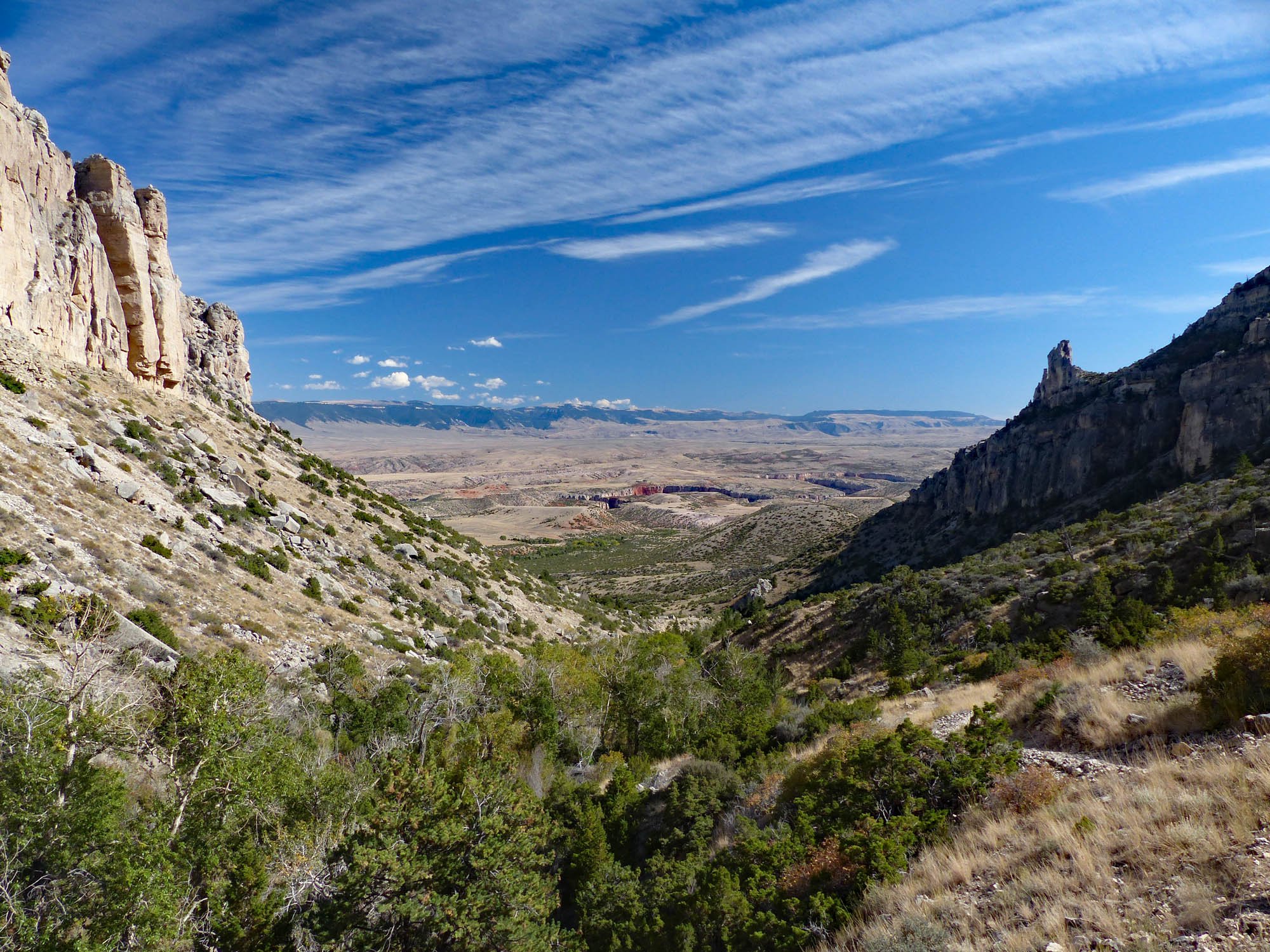
View from Layout Creek Canyon toward Bighorn Mountains.

Layout Creek Spring from the opposite side of the canyon - a good view the springs without risk to the fragile ecosystem.

One of many waterfalls at Layout Creek Springs.
Spring and fall are the best times for this great hike to Layout Creek Springs and Falls.
Download printable version of Upper Layout Creek Hiking Guide.
A short steep hike (4.4 miles round trip, elevation gain 1,300 ft.) provides superb views of Bighorn Canyon and the Bighorn Mountains framed by the precipitous limestone walls of Layout Creek Canyon. The endpoint is Layout Creek Springs - a truly unusual and special place in the arid Pryors. Layout Creek emerges from the base of the limestone cliff on the opposite canyon wall and tumbles in multiple streams and waterfalls over a steep rounded dome to the canyon bottom. Among the streams and falls are semiaquatic moss and plant gardens uncommon to the Pryors.
The stunning scenery in Bighorn Canyon National Recreation Area (BCNRA) begins at least ten miles before the trailhead. East of the Highway 37 are frequent glimpses of massive limestone walls of Bighorn Canyon. To the west the rugged 3,000 foot high east scarp of the Pryor Mountains is dramatic in the morning light.
Layout Creek, one of the few permanent streams in the Pryors, flows out of a deep canyon on the precipitous east face of East Pryor Mountain. The trail begins about a mile and a half from the rim of Bighorn Canyon.
Lower Layout Creek Trail follows the rim of the increasingly deep Layout Creek Canyon to Bighorn Canyon. The BCNRA website describes this and other hikes in the area.
At first the Upper Layout Creek Trail climbs gently but gradually steepens. After just over a mile the trail crosses to the south side of the creek climbing more and more steeply as it enters the canyon following along above the narrow riparian corridor produced by the stream. Look and listen for numerous bird species and lush riparian vegetation including cottonwood and ash trees. The trail itself is mostly above the riparian zone in juniper, sage,mountain mahogany and native grasses allowing grand views in all directions. The high vertical limestone canyon cliffs above the trail come closer together as the canyon narrows. Finally after climbing very steeply to the base of the south canyon wall, the trail enters thick timber and soon ends at Layout Creek Springs.

Wyoming sullivantia, Sullivantia hapemanii
Please treat the springs area and its unique vegetation very carefully. This is a tiny, rare and fragile riparian microhabitat in the arid Pryors. Such habitats can have great biodiversity dependent on a narrow range of environmental conditions. This includes species from plants to specialized aquatic invertebrates. For example Wyoming sullivantia (Sullivantia hapemanii) grows here and in a few similar places nearby but nowhere else in the world. This unique ecosystem is highly vulnerable to damage by human activity. Please do not walk or climb on the mossy wet dome or waterfall areas. If each visitor “accidentally” damages a few plants, there will soon be none.
Unlike most access to hikes in the Pryors, there is a good paved road all the way to the Upper Layout Creek trailhead. There is no need for a high clearance or 4WD vehicle. But from Billings MT it is a long drive around three sides of the Pryors – approximately 120 miles and over 2 hours – but it is well worth it.

Getting to the Trailhead:
Detailed Maps and Driving Directions to Pryor Mountain hiking trailheads are available on the Hiking Overview page.
From the only stoplight in Lovell WY follow Main Street (Hwy. 310) east 0.5 mile to the junction with Hwy 14.
Turn left onto Hwy. 14 at the junction. The BCNRA Visitors’ Center is on the right in 0.1 mile. It is worth a stop.
From the BCNRA Visitors’ Center drive 2.4 miles east on Hwy 14 to the brown Bighorn Canyon National Recreation Area sign at the junction with WY 37. Turn left on WY 37.
0.0 miles: Turn left (north) onto WY 37.
9.0 miles: BCNRA entrance.
15.2 miles: Turn-off to Devil’s Canyon Overlook. It's worth the detour.
19.8 miles: Turn left into onto the gravel road about 500 feet (0.1 mile) past the sign for “Ewing-Snell Historic Ranch.” The turn is not real obvious.
.It is about 1,000 ft. (0.2 mile) to the Upper Layout Creek trailhead. Drive past the toilets to the corrals and a display of old farm machinery. Park on the right opposite the corrals.
The Hike:
0.0 miles: Trailhead north of the corral. Elevation: 4,220 ft. Begin hiking on the gravel road through the gate north of the corral.
It is possible (and allowed by BCNRA) to drive the first 1.2 miles on this gravel road. The road was passible with highway vehicles (9/22/15), but was beginning to wash out a few places and had some rocks to dodge. It is only one narrow lane – passing could be a challenge. Parking is very limited at the “end.”
We recommend walking. It is a nice walk. We would like to see BCNRA close this section to public motorized use.
1.2 miles: End of gravel road. Elevation: 4,720 ft. Gain: about 500 ft.
From the end of the gravel road a two track trail turns left (south), down a short hill and swings right (west). It soon becomes a single track trail.
1.3 miles: Steel culvert and creek crossing. Part of the creek goes through a culvert. Turn left over the culvert and cross the creek. In 2015 there was brush obscuring the trail and creek crossing.

CLICK to enlarge.

1.2 miles: Foot-trail from the end of the gravel road leading to the culvert and creek crossing.

1.3 miles: The trail goes over this culvert.
Push through the brush, and follow the trail about 100 feet up out of the drainage on the south side.
The trail should then be obvious turning right (west) paralleling the creek. In 2014 BCNRA reconstructed and improved parts of the trail. It was quite clear and easy to follow in September 2015. But it’s still very steep and rocky toward the upper end. There are occasional brown trail marker posts with arrows and “Upper Layout Creek Trail.”
2.2 miles: Layout Creek Springs and falls. Elevation: 5,550 ft. Total Gain: about 1300 ft.