Rangers Trail
(Revised August 2024)

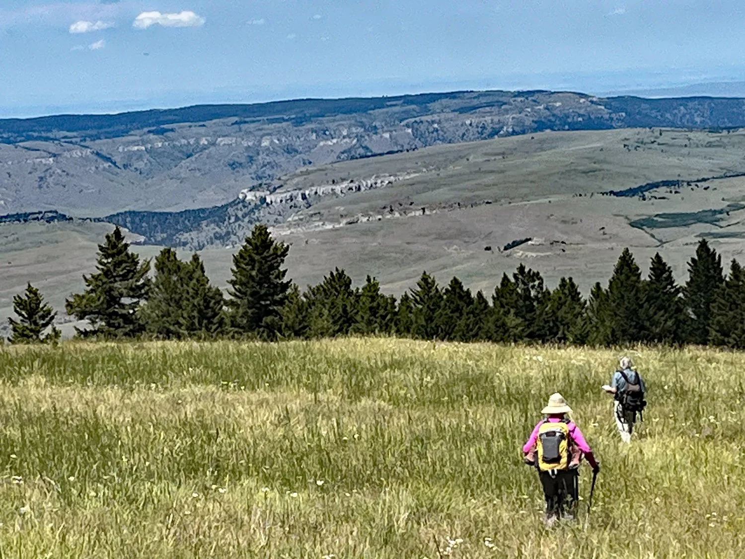
Views from Rangers Trail Meadow. (Bob Mackin photo)

Views from Rangers Trail Meadow. (Bob Mackin photo)

Views from Rangers Trail Meadow. (Bob Mackin photo)
Views from Rangers Trail Meadow. (Bob Mackin photo)

M. Webster Photos
This nearly 9 mile (round trip) hike climbs 2,500 feet elevation from Powerline Rd (~ 6,050 ft) up through thick forest on the north face of Big Pryor Mountain to the Big Pryor Plateau (~8,250 ft). The south end of the trail is at an ATV/4WD
A Primitive Trail:
Hikers should be aware that at this time the Rangers Trail is a primitive trail. Currently the trail is unsigned, little used, and frequently obscure. There is no consistently cleared trailbed. Hikers will need to pay close attention to follow the trail. A variety of clues can help. Some places it is possible to see a cleared channel through the trees, while off-trail the trees are closer together with a jumble of obstacles. On many sidehill/switchback sections the trailbed is leveled as it contours the hillside left and right of the trail. This is evidence of considerable trail work done by Forest Rangers long ago, but the trailbed shape may be obscured by vegetation. Occasionally logs sawed to clear the trail are obvious. Some places there are old, partially overgrown, blazes on trees marking the route. They are not obvious. There may be a few rock cairns. (If the trail gets more use in the future, and/or if the FS does considerable work on it, this “primitive” status may change.)
A Shorter Alternative to the full 9-mile round trip hike is to hike to a secluded and scenic meadow with great views at 7,900 feet elevation The round trip to the meadow is approximately 5 miles with about 2,000 feet elevation gain from the Powerline Rd trailhead. Most hikers will want to stay awhile exploring the meadow and views. The 15 acre meadow is bounded by thick forest on the north and west. The east boundary is above rugged limestone cliffs with great views over a deep forested and rocky canyon - and beyond. The meadow itself has abundant wildflowers of numerous species in July.
Wilderness:
The Ranger Trail crosses north-south through a mostly heavily forested part of what could, and should, be designated as the Big Pryor Wilderness Area. This 12,600 acre area includes both thick Douglas fir forest, mostly on north facing slopes, and sub-alpine plateau grassland (~8,000 ft elevation) that we call the “Prairie in the Sky.” Wildflowers are spectacular in season - late June to early August. (The Crater Ice Cave / Big Pryor Mountain Trail also provides access to this high plateau.)
The Trail Name:
The Forest Service calls this new/old trail “Big Pryor Mountain Trail.” But that is a confusing name choice. Although the Rangers Trail does go to Big Pryor Plateau, the closest it gets to the top of Big Pryor Mountain is 4 miles, and the trail’s high point is more than 500 feet elevation below the top. (The Crater Ice Cave / Big Pryor Trail does go to the top of Big Pryor Mountain.) The Rangers Trail is a historic trail constructed and used by Forest Rangers to get to the Big Pryor Plateau from the Sage Creek Ranger Station Cabin. We prefer the name “Rangers Trail,” which we learned from several Forest Service staffers, to recognize its historic use and the work done long ago to build the trail – and to avoid confusion with the Crater Ice Cave / Big Pryor Mountain Trail.
Interestingly, the Rangers Trail was “lost” for years. During development of the 2008 Custer National Forest Pryor Mountain Travel Plan, the Forest could not find the trail on the ground. So it is not mentioned anywhere in the 2008 Travel Plan or Environmental Assessment. (Nor was it in the previous 1987 Pryor Mountain Travel Plan.) Thus the Rangers Trail is not an officially designated Forest Trail. We believe it would be a good addition to the Forest Trail System, but it should first go through standard NEPA analysis, and importantly it should be limited to its traditional and historic uses of human and horse foot-travel.
Getting There – North (lower) Trailhead: (See information on the south Trailhead below.)
From highway 310 south of Bridger MT, follow Pryor Mountain Road to the Forest Service boundary. (See “Driving Directions to Pryor Mountain Hiking Trailheads” at Hiking Overview Page. ) From the boundary continue 0.25 mile SE on Pryor Mountain Road to Powerline Road (#2500) which heads straight up the hill to the south. Note: There is no sign at the Powerline Rd junction. The two-track Powerline Rd is quite obvious right at the junction, but not before or after. See photo. (The Powerline Rd junction is 0.35 mile before (i.e. NW of) the turn to Sage Creek Campground.)
No sign at junction
Powerline Road is steep and rocky. Only AWD or 4WD vehicles with appropriate ground clearance are recommended. Suitable vehicles can drive 0.9 mile up Powerline Rd to where the road makes a “U” turn down to the right. (See maps.)
Hikers without a vehicle suitable to drive up this steep two-track can park at the bottom of Powerline Rd and begin hiking up Powerline Rd. Starting the hike from Pryor Mountain Rd (5,460 ft) adds about 600 ft elevation gain, and 1.8 miles (round trip) to the hike.
In July 2024 there was a “No Motor Vehicles” sign at the “U” turn. This is the trailhead, but there was no trail sign. Park near the sign.
The Hike
Download a printable hike guide to the Rangers Trail
0.0 miles: Trailhead at the high point “U” turn of Powerline Rd. (1.0 mile up from Pryor Mountain Rd)
From the trailhead walk uphill (south) roughly parallel to a shallow drainage one or two hundred feet to the west. After about ¼ mile angle SE a little away from the drainage for another ¼ mile to the farthest south (highest) point of the open grassland. This half-a-mile in open grassland climbs about 300 ft elevation. At the edge of the trees look for a post with an old “Trail” sign missing the “T.”
0.5 miles: Trail sign at treeline and brushy “trail”.
The opening into the trees south beyond the sign is the route. The ground and trail are obscured by thick, knee-to-waist high brush. This brushy “trail” continues south about 0.2 miles into the forest climbing another 300 feet elevation to a sharp left turn.
Trail sign at treeline
The Brushy Trail
The Sharp Left Turn
0.7 miles: Sharp left (east) turn.
A more-than-90-degree left turn to the northeast on a now obvious trail. Instead of simply going uphill, the trail now contours around the hillside climbing steadily and curving to the right and east for about 0.3 miles and 250 feet elevation.
Most of the time the trailbed is flat compared to the sidehill above and below. But some places the trailbed may be obscured by vegetation.
The obvious trail after the sharp left turn.
Some places the trailbed is obscured by vegetation.
1.0 miles: The trail turns mostly south up a ridge – with occasional switchbacks toward the east and west – climbing another 800 ft elevation in about 0.9 miles.
Some examples of trail below the Meadow.
An open area through the trees. Little actual trail visible.
Considerable vegetation on trail. Obvious gap through the trees.
Margaret & Bob hiking down the switchbacks
Note sawed log and open passage through trees.
1.9 miles: The trail turns and contours, mostly west (WSW), about 0.2 miles climbing another 100 feet to the bottom (north point) of the meadow. Wander south up into the main meadow.
Be sure to notice carefully where the trail entered the meadow, to find the trail back down. (GPS Coordinates for trail from the meadow down to Powerline Rd: 45.1875°N, 108.5666°W)
2.4 miles: The Meadow.
There is no trail through the meadow. Don’t miss the rocky viewpoints NW of the first entrance, and along the east rim of the meadow.
The final stretch of trail to the meadow. (M. Webster photo)
Google Earth view of the Meadow
The trail down from the Meadow
Continuing south from The Meadow on the Rangers Trail:
The top end of the meadow is about 1/3 mile south from the bottom, and 200 ft higher elevation. Look for the trail entering the trees on the right (west) just before the upper (south) end of the meadow. There are a bunch of sawed logs just inside the woods. (See photo) (It is at about GPS coordinates 45.1832°N, 108.5644°W). It is about 2 miles to the south trailhead.
Beginning of trail beyond the meadow. Note sawed logs.
South of The Meadow the trail is in the woods most of the rest of the way. First the trail heads generally southwest climbing about 200 feet elevation to the relatively flat Big Pryor Plateau at approximately 8,200 ft elevation. The trail continues generally southeast through the forest. A good clue to help follow the trail is to note that for more than a mile this section follows close to the edge of the plateau where there is a steep drop into a deep canyon to the east. (See topo map below.) This edge is often visible from the trail though open forest. The last part of the trail shows increasing remnants of a long abandoned two-track.
Finallly the trail breaks out of the forest into open grassland. Note the barricade and post as you exit the forest (See photo).
Looking back to the barricade where trail breaks out of forest.
There is little trail visible in the grassland. Continue southeast through the grassland. Then turn south along the treeline and follow a rehabilitating two-track steeply down to a log barricade and Red Pryor Rd. Bainbridge Cabin is about 0.3 miles down this road.
View down abandoned two-track to barricade
The South (upper) Trailhead:
The second trailhead is at the south (upper) end of the Rangers trail. Few hikers will begin or end there because it is a long, slow and challenging 4WD drive to get to it. Possible 4WD routes are via Stockman Trail (#2850) from either Helt Rd south of the Pryors, or from Railbed Rd west of the Pryors. Follow Stockman Trail to its junction with Red Pryor Rd near Bainbridge Cabin. From the junction drive 0.3 miles north up the hill on Red Pryor Rd past a log barricade on the left and switchbacks to a second log barricade. The second barricade is the south trailhead for the Rangers Trail. (There is no trail sign.) From there the road makes a right turn to the east and contours to the top of the Big Pryor Plateau.
Barricade at upper (south) trailhead and Red Pryor Rd.