Vermillion Valley Geology
d. walton
Gary Thompson, Geologist, and Dick Walton
Also see Geology Tour, Pryor Mountain Road Geology Log. Pryor Mountain Road into the Pryor Mountains is a drive back through 400 million years of geologic history. The record of this history is in the sedimentary rock layers that are exposed along the road in cliffs, hillsides, and roadcuts.
Download a printable version of these notes.
How to get to Vermillion Valley Viewpoint.....
Use the Pryor Mountain Map Set to get to the junction of Crooked Creek Road and Helt Road. There are several ways to get to this point. The “Notes” with the Pryor Mountain Map Set give directions from Cowley WY (Follow Crooked Creek Rd) and from Warren MT (Follow either Helt Rd or Gyp Springs Rd to Crooked Creek Rd). Alternatively follow the Pryor Mountain Road guide from Bridger MT and turn south on Crooked Creek Rd. (The viewpoint is 14.8 miles south on Crooked Creek Road. That is 5.6 miles south of the USFS/BLM boundary fence.)
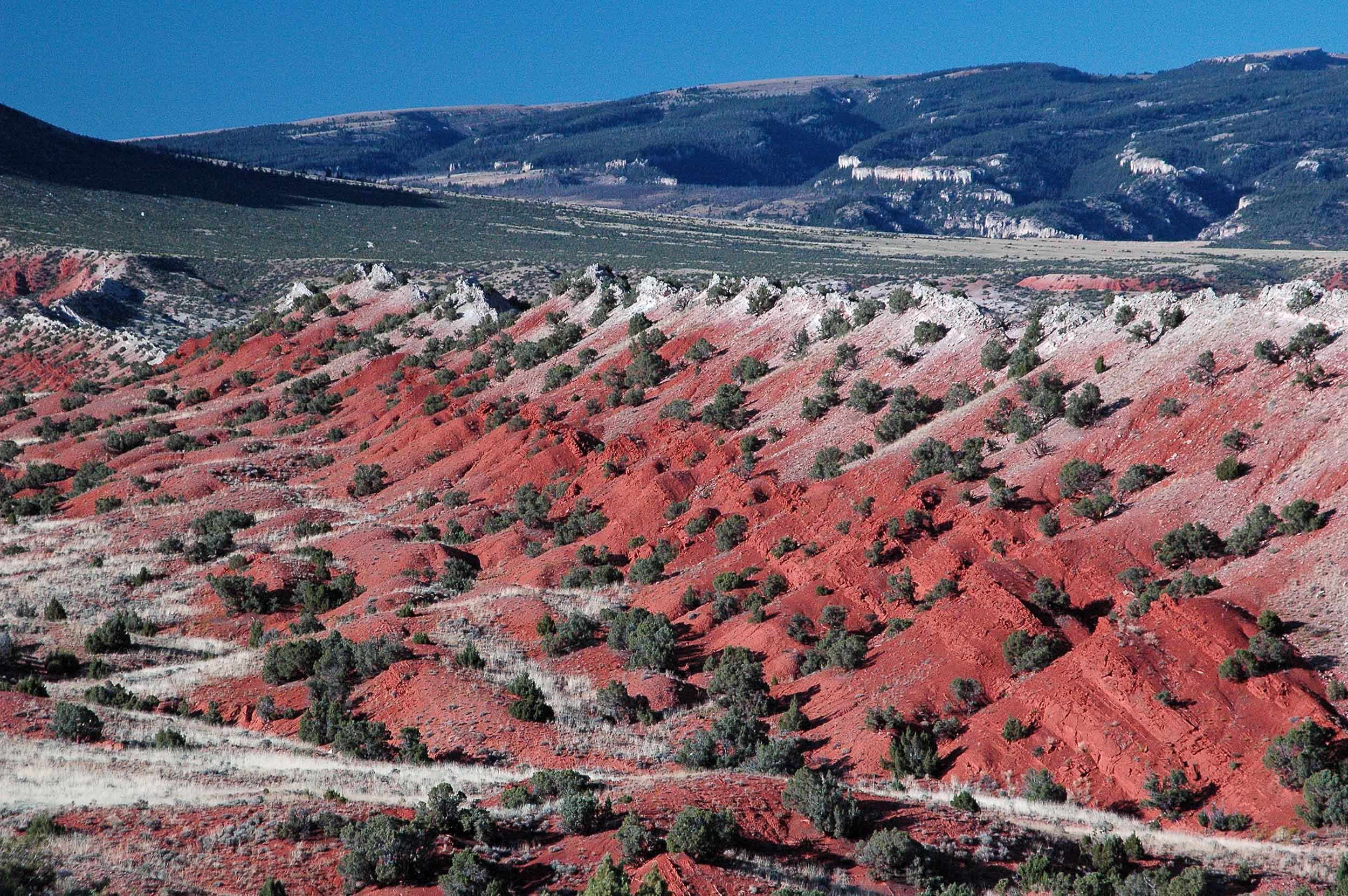
From the Crooked Creek Rd – Helt Rd junction, drive 0.6 mile north on Crooked Creek Rd and you are there. You can’t miss it! The road crests a hill and suddenly the red Vermillion Valley fills the foreground. This is it. The foreground is dominated by the north-south valley underlain by the bright red Chugwater Formation.
There is no place to park beside the road right at the viewpoint. But about 100 yards south there are a couple wide spots suitable for parking. Park and walk back (north) to the crest. Climb up road bank to the flat area east (right) of the road. The GPS coordinates of the Viewpoint are: 45.0159 N, 108.4257 W.
.The Vermillion Valley Viewpoint
In addition to providing a spectacular and photogenic view, the Vermillion Valley Viewpoint is an excellent place to learn about the geology of the Pryor Mountains. With the guidance provided in these notes you can see much of the geologic history culminating in the Pryor Mountains and their structure. The valley is named for the intense red color of the Chugwater Formation.
Why is the Chugwater Red?
The red color of the Chugwater rocks is produced by fine particles of the mineral hematite (iron oxide, Fe2O3) in the rock. Only a few percent of hematite can make a rock bright red. (Hematite is actually used as a pigment in red paint.) Hematite can form in strongly oxidizing environments at and near the earth’s surface in tropical soils, or, in acid, saline lakes, such as those presently found in southwest Australia. In these situations, many other chemical elements are leached away, leaving iron and aluminum in insoluble oxides and hydroxides. The red sediments of the Chugwater could: (1) be tropical soils, (2) have come from tropical hematite-rich soils eroded and then deposited in rivers, lakes and the sea, and/or (3) precipitated from the acid, saline lake waters and settled on the lake bottoms.
The Geologic Story of Vermillion Valley:
Over geologic time, this part of North America has slowly moved north, from straddling the equator 500 million years ago (mya) into warm temperate latitudes by 100 mya. So, much of the time tropical environments have been the norm.
Click to see paleogeographic ("ancient geography") reconstructions of the arrangement of land and sea at six different times in the last 450 million years.
Note that the Bighorn Canyon National Recreation Area is just 8 miles east of Vermillion Valley so the red star also represents the location of Vermillion Valley. The red line indicates the location of the equator.
The times of the Madison and Chugwater deposition are included in the illustration. The Gypsum Spring Formation in the illustration was deposited about the same time as the Piper in Vermillion Valley. The Bighorn Dolomite can be seen on the face of Big Pryor above Crooked Creek Road a few miles north from Vermillion Valley. The Frontier Formation crops out elsewhere in the Pryors. (See the Pryor Mountain Road Geology Tour.)
These reconstructions were done by Ron Blakey of Colorado Plateau Geosystems, Inc., which is online at http://cpgsystems.com/paleomaps.html.
This illustration is taken from:Kellerlynn, K. 2011. Bighorn Canyon National Recreation Area: geologic resources inventory report. Natural Resource Report NPS/NRSS/GRD/NRR—2011/447. National Park Service, Fort Collins, Colorado, U.S.A.
The entire report is available at: http://www.nature.nps.gov/geology/inventory/publications/reports/bica_gri_rpt_view.pdf
Figure 1: Vertical cross-section of the originally horizontal layers visible from the Viewpoint (now folded and eroded). Other layers above and below, not shown here, are shown in the Stratigraphic Column.
Figure 2: Vertical cross-section of the layers shown in Figure 1 after folding and showing anticlines and syncline.
Horizontal Layers
The rocks visible from this viewpoint were originally deposited in a sequence of horizontal layers (Figure 1) over a period of some 200 million years during the Mississippian, Pennsylvanian, Permian, Triassic, Jurassic and Cretaceous Geologic Periods from more than 300 mya to 100 mya. During much of this time this part of the future Montana was covered by a shallow sea. Several thousand feet of sediments settled to the seafloor; or in lakes, rivers and marshes at times when the sea had receded. The rocks we now see are records from those hundreds of millions of years.
Layers Tilt and Fold
70 to 55 million years ago (mya) movement of tectonic plates caused an east-west compression of the earth’s crust. Resulting thrust faults in the metamorphic and igneous basement rocks forced the overlying sedimentary layers to tilt and fold. After this compression a vertical, east-west cross-section of these sediments would have shown the layers to be folded (Figure 2). As a result each layer was now shaped like a large letter “M” leaning hard toward the east. Bends which are convex upward are called anticlines. Concave upward bends are called synclines. In this case they are called asymmetric folds since, from west to east, they rise gently and fall steeply.
Uplift and Erosion
The crests of these two anticlines would much later become Big Pryor and East Pryor Mountains. Approximately 20 mya the whole area began to be lifted to higher elevation and the top layers began to erode away. Most of the younger layers on top of the thick Madison have eroded away on the upper west-facing slopes leaving the Madison limestone as the surface layer for much of the Pryors. This surface is cut by many rugged and deep canyons. Because of the asymmetry of the original folding the west facing slopes of both East Pryor and Big Pryor Mountains are gentle, but the east facing slopes are steep and cliffy.
From the Vermillion Valley Viewpoint, we see to the northeast the gentle west facing slopes of East Pryor Mountain with rugged canyons eroded into the limestone. To the northwest we see the steeper east face of Big Pryor Mountain (Figure 3). The unseen (from the viewpoint) west face of Big Pryor Mountain is similar to the west face of East Pryor, and the unseen east face of East Pryor Mountain is similar to the east face of Big Pryor. Crooked Creek Canyon runs from north to south between these two mountain blocks and passes to the east of the viewpoint.
Figure 3: View north from Vermillion Valley Viewpoint. Black lines indicate approximate contacts between formations in all photos. Click to enlarge.
Vermillion Valley is Different
The older Madison Limestone forms the surface of the higher parts of the Pryors seen in the distance, north from the viewpoint. But in the lower elevation foreground seen from the viewpoint, the Madison is far under ground – covered by younger rock layers which have been eroded from the high peaks, but not here at Vermillion Valley. To understand why this is true see the discussion of “Plunging Folds” below.
Figure 4: Vertical cross-section of the Vermillion Valley structure today. The part of the fold in red has been eroded away. The right part of the diagram is too far east to be visible from the viewpoint. The diagram was constructed based on field measurements.
As a result of the geologic history outlined above we can now see, in one view from the Vermillion Valley Viewpoint, surface exposures of many different geologic formations instead of just the top layer of a horizontal layer cake. Here many younger layers deposited on top of the Madison Limestone are steeply tilted on the east side of the Big Pryor anticline (Figure 4).Erosion has cut a relatively horizontal surface across the area leaving eroded remnants of the folds. The ridges are composed of rock layers that resist erosion while the valleys are underlain by less resistant rocks. In this view the ridge formers are limestones and sandstones of the Madison, Amsden, Tensleep, Swift and Piper. The steeply dipping (up to 600) resistant layers result in steep sided ridges called hogbacks.As uplift of the area has occurred, the rivers and their tributaries, with steeper gradients, have cut into the rocks. More powerful streams have been able to cut gaps through some of the ridges (See where the road passes through such a gap in Figure 5.), but mostly the streams cut their beds in less resistant rocks. The streams seen here are essentially all ephemeral, being dry most of the time.
Click for Info on the Geologic Formations visible from the Vermillion Valley Viewpoint.
Reading Geologic History
Looking north from the viewpoint, we see in the foreground, scanning west to east (left to right), a record of more than 150 million years of geologic history. In sequence we see the progressively younger formations: Tensleep, Phosphoria-Goose Egg, Chugwater, Piper, Rierdon, Swift, Morrison and Kootenai Formations. During this time the sea covering this part of the future Montana repeatedly receded and advanced. Geologists see this in the types of sediment deposited and in the fossils they contain.
The Tensleep Sandstone was deposited partly on a shallow seafloor nearshore and partly as wind laid sand dunes inland, but near the coast. The Phosphoria Formation here was deposited on a shallow sea floor, while the Goose Egg Formation was deposited nearshore in more saline water perhaps in shallow lagoons or lakes or on adjoining mud flats. The Chugwater is very similar to the Goose Egg and was likely deposited not far from the sea in ephemeral lakes and small streams.
The Piper limestones in the hogback represent an incursion of the sea across dry land. Above the Piper, the Rierdon and Swift represent a continuation and shallowing of that sea. Then, the Morrison represents coastal plain deposits after the sea receded.
Actually, if we were to look very closely at this Tensleep-Morrison interval, we could see evidence for several smaller fluctuations in sea level as well.
There is interesting additional information in the following charts. Look for the formations mentioned above. These charts are part of a report by the National Park Service for the Bighorn Canyon National Recreation Area - just 8 miles east of Vermillion Valley.
Gypsum is Special
Chemically, the mineral gypsum is hydrated calcium sulfate (CaSO4 . 2H2O). Gypsum beds are found in the Goose Egg, Chugwater, and Piper formations, interlayered with sedimentary rocks such as sandstone, shale, and limestone. The soft, fine-grained beds of gypsum cropping out in this area are snow white, but are usually covered by mud washed down from soils above.
Although less soluble than rock salt (halite, NaCl), gypsum is more soluble in water than most other rock forming minerals. It commonly forms by precipitation from saline water as the water evaporates. Evaporating 1,000 meters of normal seawater yields less than a meter of gypsum. Within a mile of this viewpoint there is a 10 meter thick layer of gypsum at the base of the Piper Formation.
The presence of these gypsum beds indicates special climatic and geographic conditions in the ancient world. They require an arid climate providing a high rate of evaporation, and a partial barrier to retain concentrated brine in an isolated arm of the sea or a saline lake near the sea.
Because gypsum is relatively soluble in water, it usually does not last long exposed at the surface of the earth, except in arid regions like the south Pryor desert.
Figure 5: View north along the ridge of the Piper Formation east of the VV Viewpoint. The black line between the Chugwater and the Piper is the 70 million year gap.
A Gap in the History
There is an approximately 70 million year gap between the Chugwater and the Piper Formations. This is called an unconformity. What happened here during those 70 million years? The geologic record is missing. Perhaps more sediments were deposited on top of the Chugwater. If they were, they were eroded away before changing conditions allowed the deposition of the Piper.
At the viewpoint you are standing on the red Chugwater Formation. If you walk a few hundreds yards to the east, to the top of the ridge, you will be standing on the Piper Formation. In between you will have crossed the unconformity – the 70 my gap in the geologic record. “Mind the gap.”
Figure 6: View northwest from the viewpoint showing the Tensleep Formation draping over the crest of the anticline.
Plunging Folds
The two anticlines and the syncline in the Pryors are also slightly tilted down toward the south. Geologically, these structures are referred to as south-plunging asymmetric folds.
From the Vermillion Valley Viewpoint we can see the crest line of the plunging anticline. (Figure 6) The resistant Tensleep Sandstone drapes over the crest, dipping steeply eastward on the east side and dipping more gently westward on the west. The crest line plunges gently southward. The red patch farther to the north up Big Pryor Mountain in the center right is the underlying Amsden Formation. The Tensleep, originally above the Amsden, has eroded away exposing the Amsden. Higher (and farther north) still is the Madison Limestone originally deposited beneath the Amsden. There even the Amsden is eroded off the anticline. Because the anticline plunges to the south, or rises to the north, we see older layers exposed farther north.
Figure 7: Red lines represent one layer in a plunging anticline-syncline fold. Black indicates a horizontal erosional surface. Note thick black zigzag where folded layer intersects horizontal plane.
Figure 8: The ZigZag pattern of geologic formations in the Google Earth view indicates a plunging anticline and syncline. The Yellow pin marks Vermillion Valley Viewpoint. Note Crooked Creek, Helt, and Gyp Springs Roads shown in blue.
To the south, southwest of the viewpoint, the Tensleep also disappears under younger layers just as the Madison does.
Notice on the sketch of plunging folds (Figure 7) that a horizontal erosional surface exposes each formation as a “V” shape pointing in the direction of the plunge for anticlines, and opposite the plunge direction for synclines. For an anticline-syncline pair this makes a zigzag. The view from Google Earth (Figure 8) vividly shows this pattern in the Vermillion Valley area. Although someone walking around the area of Vermillion Valley would do a lot of climbing up and down on the human scale, on the scale of the folds and the Google Earth view the surface is quite flat. See the erosional surface in Figure 4.
Because the anticline is asymmetric with a gentle west and steep east slope, the west branch of the “V” is wide and the east branch is narrow on the Google Earth view.
For more information on the geology of the Pryors see the Pryor Mountain Road Geology Tour.
Sources
Kellerlynn, K., 2011. Bighorn Canyon National Recreation Area: geologic resources inventory report. National Resources Report NPS/NRSS/GRD/NRR-2011/447. National Park Service, Fort Collins, Colorado, U.S.A. www.nature.nps.gov/geology/inventory/publications/reports/bica_gri_rpt_view.pdf
Lopez, D. A., 2000. Geologic map of the Bridger 30′ x 60′ quadrangle, Montana: Montana Bureau of Mines and Geology: Geologic Map 58, 1 sheet(s), 1:100,000.
United States Geological Survey, 2014. Geologic Names Lexicon (Geolex). http://ngmdb.usgs.gov/Geolex/search.
Vuke, S. M., Wilde, E. M., Lopez, D. A., and Bergantino, R. N, 2000 (revised 2007). Geologic map of the Lodge Grass 30′ x 60′ quadrangle, Montana: Montana Bureau of Mines and Geology: Geologic Map 56, 1 sheet(s), 1:100,000.
Wilmarth, M. Grace, 1957. Lexicon of geologic names of the United States: U.S. Geological Survey Bulletin 896, parts 1 and 2.
Wilson, Druid, Sando, William J., and Kopf, Rudolph W., 1957. Geologic names of North America introduced in 1936-1955: U.S. Geological Survey Bulletin 1056-A.