Geology Tour
Pryor Mountain Road Geology Log
by Gary Thompson, PhD, Geology
photos by Dick Walton
Also see Vermillion Valley Geology. The Vermillion Valley Viewpoint at the south end of Crooked Creek Valley provides a spectacular and photogenic view. It is an excellent place to learn about the geology of the Pryor Mountains through the trained eyes of a geologist. From this one easily accessible viewpoint, 200 million years of geologic history culminating in the Pryor Mountains and their geologic structure are visible.
Introduction to a Drive Back Through Time
Download a Printable Geology Tour Guide, Stratigraphic Chart, and Stratigraphic Column.
Pryor Mountain Road from Highway 310 south of Bridger MT into the Pryor Mountains is a drive back through 400 million years of geologic history. The record of this history is in the sedimentary rock layers that are exposed along the road in cliffs, hillsides, and roadcuts.
Ancient Seas
From about 500 million years ago until about 70 million years ago (mya), this area was covered by ocean much of the time. Early on, from 500 mya to about 200 mya this area was on the western edge of ancestral North America. As sea level rose and fell, the ocean shoreline advanced to the east and receded to the west several times. From about 200 mya until about 70 mya, an inland sea, connected to the world ocean, lay here with land to the west as well as to the east. As sea level repeatedly rose and fell, the inland sea widened and narrowed. So this area was sometimes in deep water, sometimes in shallow water, and sometimes on dry land. This is reflected in the kinds of sediment (now sedimentary rock) that were accumulating here. The fossils in these rocks reveal repeated change in the life in the sea and on the land as organisms went extinct and new ones evolved.
Sediments Become Rocks
When this area was covered by the sea, sediments eroded from the adjacent land or precipitated from the sea water were gradually deposited on the sea floor leaving a record of the conditions at that time. The kind of sediments depended on several factors, such as the depth of the water, the distance out to sea, and the climate, as well as the topography of the land area from which sediment was eroded. When this area was above sea level, sediments were deposited here and there in rivers, swamps, and lakes; while some of the previously deposited record was eroded away to the sea elsewhere. The different sediment layers are like the pages of a geologic history book. As the layers built up, slowly seeping groundwater deposited mineral cement in the pores, and pressure compacted the deeper layers turning sediment into rock.
Rocks Rise from the Sea
About 70 mya the area of the Pryors began to gradually rise and tilt. The inland sea disappeared. The rock layers, originally deposited horizontal, were lifted more to the northeast than to the southwest. So the pages of the geologic history book were tilted down toward the southwest. The same rock layers which form the top of the Pryors slope downward and are about 5,000 feet under Highway 310. At the same time the land was rising and tilting, erosion worked to level the land, cutting across the tilted layers. The result is that as we drive east toward the Pryors we generally cross from layer to layer seeing older and older pages of the geologic history book. However, we do see some interruptions in this general sequence as we cross faults and folds that were created here and there where rock layers bent or cracked and shifted during the uplift and tilting.
We hope this Geologic Road Log will help you read those pages.
The Geology Tour
This Geology tour begins where Pryor Mountain Road leaves Highway 310 three miles south of Bridger MT. It follows the same route as the Driving Tour of the Pryors so those directions and map may be helpful. Note that the map colors show land ownership. Landowner's permission is required to leave the road onto private or Crow land.
As you drive along, referring to the Stratigraphic Chart and the Stratigraphic Column will help you keep track of the names, the ages and the sequence of the sedimentary layers.
At some points in this road log, directions are denoted according to the face of a clock, with 12:00 in the direction the car is headed. 3:00 would be straight to the right, 9:00 straight to the left, and 6:00 straight back. Also, note that odometers vary, so your vehicle’s mileage could be slightly different from ours. Mileages given for cattle guards are an opportunity to re-sync odometer readings.
0.0 miles: Junction of Hwy. 310 and Pryor Mountain Road. The surrounding flat surface is a stream terrace along the Clark’s Fork of the Yellowstone River and a tributary, Bridger Creek. This surface is an old floodplain formed when the river flowed at a higher level during the Quaternary period before it eroded down to its present level. Quaternary refers to the most recent Geologic Period making up the last 2.6 million years.
0.05 mile: Cross Bridger Creek. Notice how this small creek has eroded down, well below the terrace surface.
2.0 miles: Paved road ends. Cross railroad tracks.
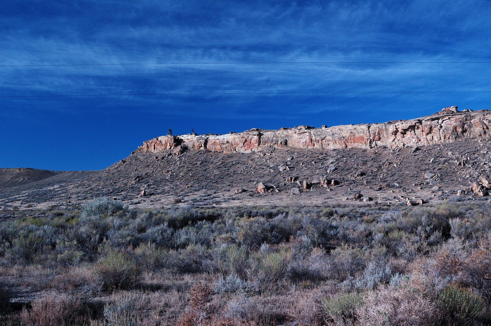
2.6 miles (just before right turn in road): Looking straight ahead up dip slope on sandstone in lower Frontier Formation (Cretaceous age). Hillside exposure of sandstone beds in the lower Frontier Formation dipping to southwest at about 15 degrees in distance at 9:00. In this area the bedrock strata dip (are inclined downward) uniformly to the southwest, except where there are localized faults and folds (as for example, at Red Dome, which we will see ahead). Road turns right.
2.6 miles, 9:00: Hillside exposure of Frontier Formation dipping to southwest at about 15°
2.8 miles, 9:00: Exposure of sandstone in the Frontier Formation.
3.3 miles, right: Cliff on skyline is Frontier Formation sandstone.
Dip is the vertical angle that an inclined plane surface makes with a horizontal surface; the amount of tilt. The surface of a sedimentary layer is assumed to be planar, and we speak of a tilted layer as dipping. The direction of dip is the downward direction. A dip slope is a planar hillslope that is everywhere underlain by a dipping, erosion-resistant rock layer.
The word “formation” usually is very narrowly defined in geology. In geology a formation is a mappable lithostratigraphic unit (a distinct rock layer or series of rock layers). Mappable means that its top and its bottom can be represented by two separate lines on a geologic map. The name of a formation consists of the word “Formation”, or the name of the dominant rock type in the formation, with a capital letter, preceded by a geographical name. For example, the Frontier Formation, where Frontier is a town in southwestern Wyoming near where the formation was first described in 1902. The outcrop of this formation near the town of Frontier is referred to as the type locality of the formation. Another example of a formation name would be the Mowry Shale.
The Frontier Formation comprises inter-layered sandstone, mudstone, and coal. It’s about 500 feet thick. These rocks were deposited in the area of the Pryors as sediment, from about 93 mya to about 89 mya (Late Cretaceous), on a river delta and the seafloor offshore. The river entered the inland sea from the west and built its delta eastward. The Frontier contains fossils of marine ammonites, oysters, and other mollusks; as well as nonmarine plant fossils. Coal is mined from the Frontier in southwestern Wyoming, and oil and natural gas are produced from it in the Bighorn Basin and elsewhere.
2.8 miles: Good exposure of sandstone in the lower Frontier Formation on left surrounding home and yard. This layered yellowish tan rock resists erosion, and is what underlies and holds up the ridge above the home.
2.9 miles: Following along Bridger Creek on our right, we pass through a gap in the ridge. Bridger Creek has eroded through the tilted Frontier Formation to produce this gap in the ridge.
3.3 miles: Cliff on right on skyline is again sandstone in the lower Frontier Formation. The low flats along Bridger Creek are underlain by Quaternary alluvium that covers the older Belle Fourche Formation.
Alluvium is a deposit of unconsolidated gravel, sand, silt, or clay left by a river.
The Belle Fourche Formation comprises gray to black shale. It’s 350 to 400 feet thick in this area. The mud from which this shale was formed was deposited on a seafloor well offshore about 99 mya to 93 mya. Belle Fourche fossils include ammonites and bivalves. It was named for Belle Fourche Creek, Crook County, Wyoming in 1920.
3.8 miles: Driving along an east-west fault zone where the outcrops of the tilted Frontier and other formations on the right side of the road have shifted back to the west.
4.4 miles: To right at 2:00 on distant slope, thin sandstone cliff of Frontier Formation on skyline overlies long slopes of Belle Fourche Shale and Mowry Shale.
Shale is a fine-grained sedimentary rock composed of clay and silt size particles, and that usually splits into thin flat fragments; a fissile mudrock. Shale is easily eroded and normally does not form ledges or cliffs as does sandstone and some other rocks.
The Mowry Shale comprises light gray to silver-gray shale interbedded with very thin beds of siltstone and sandstone. It is about 250 feet thick in this area. Bentonite beds are common and are mined north of the Black Hills in South Dakota. Fish scales and bones are abundant in some beds. It was named for Mowrie Creek, near Buffalo, Wyoming in 1904.
4.4 miles, 11:00: Dip slope of Pryor Conglomerate Member of the Kootenai Formation, covered with scattered limber pines. Pryor Conglomerate boulders have slid down the underlying Morrison
From 11:00 to 12:00 is dip slope on the Pryor Conglomerate Member of the Kootenai Formation (Cretaceous age), covered with scattered limber pines. At 10:00 is the red Chugwater Formation (Triassic age) exposed (beyond the ranch buildings) in the eroded core of Red Dome, at which we’ll get a closer look down the road. The strata dip away from the dome’s center, like an inverted set of nested bowls. A member is a distinct part of a formation, considered too thin to map as a separate formation.
In this area the Kootenai Formation comprises the lower Pryor Conglomerate Member and the upper member of the Kootenai. The Pryor Conglomerate Member comprises brown conglomerate and pebbly sandstone 20 to 60 feet thick.The upper member of the Kootenai comprises reddish, purplish, and greenish shale interbedded with tan sandstone and thin gray limestone. The total thickness of the Kootenai is 200 to 250 feet.
4.4 miles, 10:00: Red Chugwater Formation exposed in the eroded core of Red Dome.
The sediments of the Kootenai were deposited in rivers and lakes during the early Cretaceous Period. Kootenai fossils include plants, freshwater mollusks, and dinosaurs. The dinosaur Deinonychus, a 10 foot long predator, was discovered in the Kootenai just a few miles from Pryor Mountain Road in 1964, and has been important in establishing the close relationship between dinosaurs and birds. The Kootenai Formation was named in 1885 after the Kootanie Tribe for rocks exposed in southern Alberta. In Wyoming the Kootenai is called the Cloverly Formation.
4.6 miles: Cross cattle guard.
5.0 miles, right: Fall River Sandstone in low cliff beyond creek. Frontier, Belle Fourche, and Mowry are seen in the hills beyond.
5.6 miles, 9:00: Morrison Formation. The tan sandstones form ledges and cliffs, while reddish and gray mudstones erode into gentler slopes.
5.0 miles: Pryor Conglomerate Member of the Kootenai Formation on left and under the road. Limber pines are common on the outcrops of the Pryor Conglomerate where water collects in the many pores and cracks. Fall River Sandstone in low cliff beyond creek to right. Frontier, Belle Fourche, and Mowry are seen in the hills beyond.
The Fall River Sandstone comprises tan sandstones interbedded with gray shale. These sediments were deposited in rivers and on the near shore seafloor during the early Cretaceous Period. Here the Fall River is less than 50 feet thick. The Fall River Sandstone was named for rocks exposed along the Fall River near Hot Springs, South Dakota in 1927.
5.6 miles: Sandstones and mudstones of the Morrison Formation (Jurassic age) on left all the way to skyline at 9:00. The tan sandstones form ledges and cliffs, while reddish and gray mudstones erode into gentler slopes.
The Morrison Formation comprises tan sandstone, gray to reddish shale, coal, and thin gray limestone. These sediments of the Morrison were deposited in rivers, lakes and swamps during the late Jurassic Period. Fossil dinosaurs are common in the Morrison. Near Pryor Mountain Road, a large number of disarticulated bones of juvenile Diplodocus-like sauropods were found in the Morrison in 1994. These were interpreted as the remains of a herd of young animals of a single species. (See: Fossil site near Pryor Mountains reveals dinosaur die-off.) Here the formation is about 300 feet thick. The Morrison was named for outcrops near the town of Morrison, Colorado, near Denver, in 1896.
5.9 miles, 9:00: Thin bit of lower Morrison Formation at top, underlain by tan cliff of Swift Formation, gentle grayer slope of Rierdon Formation, thin white limestone ledge and reddish mudstones of Piper Formation. Dip is to the west at about 30° Boulder covered small hills at base of slope are landslides.
5.9 miles: From 8:00 to 11:00, exposures of Morrison, Swift, Rierdon, and Piper Formation (all of Jurassic age); and Chugwater Formation (Triassic age), all dipping to the southwest. At 3:00, across creek is hillside exposing sandstones of the upper Kootenai Formation which is on the other side of an east-west cutting fault that crosses under the creek here. The Kootenai has moved down relative to our side of the fault.
The Swift Formation is about 100 feet thick, comprising tan sandstone and some gray shale. These sediments were deposited nearshore in the late Jurassic sea. Common fossils include oysters and belemnites. The Swift Formation was named in 1945 for exposures along Swift Reservoir in Pondera County, Montana. In Wyoming, the rocks of the Swift are considered part of the Sundance Formation.
5.9 miles,10:00: Dip slope on limestone of middle Piper Formation with scattered limber pines.
The Rierdon Formation is about 150 feet thick and is made up of mostly gray shale and thin gray limestones originally deposited offshore in the Late Jurassic sea. Fossils include abundant oyster-like mollusks and belemnites, as well as fish and ammonites. The Rierdon was named in 1945 for outcrops in Rierdon Gulch along the Rocky Mountain Front in Teton County, Montana. In Wyoming, rocks of the Rierdon are considered part of the Sundance Formation.
The Piper Formation comprises about 100 feet of reddish shale, gray shale, gray limestone and white gypsum. The reddish shale and some gray shale were deposited in fresh or brackish lakes. The limestones and other gray shales were deposited on the Middle Jurassic seafloor. The gypsum was deposited from highly saline water. Fossils include oysters and other bivalves, corals, and crinoids.
5.9 miles, 11:00: Red Chugwater Formation exposed in eroded core of Red Dome.
The Piper Formation was named in 1945 for rocks exposed near Piper, Montana, on the north side of the Big Snowy Mountains.
The Chugwater Formation comprises about 500 feet of red shale, siltstone, and sandstone likely deposited in ephemeral lakes and small streams during the Early Triassic. It is essentially without fossils. The Chugwater was named for rocks exposed along Chugwater Creek near Iron Mountain, Wyoming, in 1904.
The Thermopolis Shale is dark gray shale originally deposited as offshore mud on a stagnant oxygen-deprived sea floor during the Early Cretaceous. The formation is about 600 feet thick. Fossil shark teeth and plesiosaurs have been found in the Thermopolis. The Thermopolis Shale was named in 1916 for outcrops near Thermopolis, Wyoming.
6.1 miles, 1:00 to 2:00: Long ridge with a thin ledge of Frontier Formation at the very top underlain by slopes of Belle Fourche, Mowry Shale and Thermopolis Shale.
6.6 miles (before left turn in road): Dip slope on Fall River Sandstone straight ahead.
7.2 miles, left: Red mudstones in upper Kootenai Formation in hillside.
6.1 miles: The long ridge from 1:00 to 4:00 with a thin ledge of Frontier Formation at the very top is underlain by slopes of Belle Fourche, Mowry and Thermopolis Shale (Cretaceous age).
6.6 miles (before left turn in road): Dip slope on Fall River Sandstone straight ahead.
6.7 miles (after left turn in road): Pryor Conglomerate at 11:00 to 1:00 on skyline straight ahead, with its scattered limber pines.
7.2 miles: Red mudstones in upper Kootenai Formation in hillside to left.
7.4 miles, left: Close-up of pebbles in Pryor Conglomerate.
7.7 miles: Red mudstone of Piper Formation in road cut on right; limestone of Piper on left.
7.4 miles: Exposures of Pryor Conglomerate in “narrows” (guardrail on left) on both sides close to road.
Close up the conglomerate is distinct with a variety of pebbles many of which are dark chert. Chert is a hard very fine-grained sedimentary rock composed of tiny interlocking quartz. These particular dark chert pebbles are fragments eroded from older formations such as the Phosphoria Formation, uplifted and exposed at the time in southwestern Montana and Idaho. These fragments were carried east by braided rivers, rounded, and deposited in the area of the Pryors.
The Phosphoria Formation here comprises less than 10 feet of pinkish gray limestone and hard tan sandstone embedded with gray chert masses. These sediments were deposited on a shallow sea floor during the Permian Period. The Phophoria was named in 1912 for rocks exposed along Phosphoria Gulch in southeastern Idaho.
7.9 miles, left: Gray tar-impregnated sandstone in Chugwater Formation.
8.0 miles, 7:00 to 8:00: Red Chugwater Formation overlain by pink Piper Formation. The unconformity between is a gap in the geologic record of about 70 million years.
Limestone is a sedimentary rock composed chiefly of the mineral calcite, a calcium carbonate mineral.
7.9 miles: At 8:00 is the exposed center of Red Dome. The deep red siltstones and sandstones of the Chugwater Formation are exposed at the center of this eroded doming of strata. Note that the strata are dipping in all directions away from the center. Above the Chugwater is the paler, pink lower Piper Formation. Even small amounts of iron oxide can give rocks a reddish color. One source of the iron oxide is from deeply weathered tropical soils that existed at that time. There are some gray streaks in these reddish rocks that are impregnated with deposits of tar. The tar is a residue of crude oil that was once trapped under an impermeable layer of gypsum in the dome.
The Chugwater was deposited not far above sea level. After the Chugwater was deposited, uplift occurred and/or sea level dropped, and erosion carried away some of the rock record. Then, following subsidence of the land and/or a rise in sea level, the Piper was deposited, partly just above and partly just below sea level, on what was left of the Chugwater. This preserved an unconformity representing a gap of about 70 million years.
An unconformity is a surface that separates a sedimentary rock layer from underlying rock and represents time during which no sediment was deposited, or, sediment or rock that had been formed was removed by erosion before the overlying layer was deposited. It’s a gap in the rock record. In most cases an unconformity represents a period of erosion.North America geologists recognize three types of unconformities. (1), A nonconformity is an unconformity separating plutonic or metamorphic rock below from sedimentary rock above. (2), An angular unconformity is a surface separating the eroded edges of tilted strata below from horizontal strata above. (3), A disconformity is an unconfomity separating parallel strata. Generally, nonconfomities represent the longest gaps, angular unconformities represent shorter gaps, and disconformities represent the even shorter gaps. All the unconformities encountered along Pryor Mountain Road appear as disconformities. On the east face of East Pryor Mountain a nonconformity separates metamorphic rock from overlying sedimentary rock, representing a gap of about 2 billion years.
8.3 miles, left: Steeply dipping, densely fractured limestone beds in Piper Formation close to road.
8.3 miles: Limestone beds on left dipping steeply towards road are densely fractured close to the large east-west fault running under the road. These beds have been bent down and fractured along the fault suggesting that the limestone, on the north side of the fault, has moved up relative to south side.
8.5 miles: Cross cattle guard. First view of the crest of Big Pryor Mountain on skyline ahead
9.4 miles: Outcrop of Pryor Conglomerate on left; outcrop of Swift Formation below on right. East-west fault under road. Good view of Big Pryor Mountain ahead..
9.4 miles, straight ahead: Bowler Flat and Big Pryor Mountain. The southwest slope of Big Pryor is the dip slope of Madison Group limestone. This photo was taken before the large wind farm was installed in 2020.
9.6 miles: Cattle guard.
The broad southwest side of Big Pryor represents the dip slope of the Madison Group limestone. Rising to the northeast the erosion-resistant Madison reaches over 8000 feet at the top of Big Pryor. The north face of Big Pryor Mountain, and of East Pryor Mountain beyond, is aligned with us along a deep east-west fault zone. From here, near Red Dome, this fault zone continues along a line all the way west to the neighborhood of Nye, Montana. Geologists call the long straight topographic feature, that reflects this large deep fault zone, the Nye-Bowler Lineament. As here at Red Dome, there are domed structure at other places along the fault zone of the Nye-Bowler Lineament. There is evidence for horizontal movement along this fault zone. That is, the rocks on the north side of the fault zone moved west relative to those on the south. A simple analogy used to explain the creation of elongate domes along fault zones can be demonstrated with a piece of cloth. With your hands placed a couple inches apart on a loose piece of cloth underlain by a firm surface, slide one hand forward and notice the folds that develop in the cloth. In more brittle rock, cracks (faults) would also form. In the low area at 2:00 to 4:00 are several dip slopes (dipping to the southwest) on resistant layers in the Jurassic (Morrison, Swift, Rierdon, and Piper Formations).
11.8 miles, right: Tensleep Sandstone outcrop on hillside.
9.7 miles: Black Butte, a dome capped by Tensleep Sandstone (Pennsylvanian age), at 2:00. Bowler Flat lays out before us.
The Tensleep Sandstone is composed of about 200 feet of white to light tan, fine-grained, quartz-rich sandstone. The sand was deposited on a shallow seafloor nearshore and as wind laid dunes near the shore during the Pennsylvanian (Late Carboniferous) Period. The Tensleep was named in 1904 for rocks exposed in Tensleep Canyon, Wyoming. Crude oil is produced from the Tensleep in the subsurface of the Bighorn Basin.
16.3 miles, left: Tensleep Sandstone outcrop.
11.5 to 11.8 miles: Tensleep Sandstone crops out on hillside to right.
12.2 miles: Road Junction at old town site of Bowler. Power transformers on right. Turn to left, continuing on Pryor Mountain Road. We are on Bowler Flat which is underlain by alluvium and represent in part the flood plain of the ancestral Shoshone River that flowed from Wyoming to the northeast through Pryor Gap which can be seen to the northeast. The old flat flood plain has been buried by younger alluvial fan deposits that washed in from the surrounding high areas.
15.0 miles: Enter Crow Reservation.
16.1 miles: Cattle guard.
16.3 miles: Tensleep Sandstone crops out in cliff on left.
16.6 miles, 9:30: Cliffs of Madison Group limestone (right) dipping to the west overlain by reddish Amsden Formation (left)
16.6 miles, 10:30: View into Pryor Gap with Madison Group cliffs of Castle Rocks in distance.
16.6 miles, 1:00 to 3:00: View of the north face of Big Pryor Mountain
16.6 miles: Cross road on old railroad grade. Castle Rocks appear in distance through Pryor Gap at 10:00. Castle Rocks are limestone cliffs of Madison Group (Mississippian age). Reddish slope in Amsden Formation (Pennsylvanian age) at 9:30. From 1:00 to 3:00 is the north face of Big Pryor Mountain. Limestone of the Madison Group at the top of Big Pryor Mountain, is bent and faulted down along Big Pryor’s north face to our level along Sage Creek. From Sage Creek northward, the Madison rises only slightly into the northern Pryor Mountains on the Crow Reservation. In much of this area, erosion has cut down to the Madison. Erosion is so impeded by this thick resistant Limestone that the rock determines the general topography.
In geology a “Group”, with a capital G, is a stratigraphic unit that includes two or more similar formations. The Madison Group comprises two formations exposed in Montana, an upper Mission Canyon Limestone, and a lower Lodgepole Limestone. Both of these formations consist of gray limestone, the Mission Canyon being massive and thick-bedded, the Lodgepole thin-bedded. The total thickness of the Madison in this area is about 1000 feet. Common fossils include brachiopods, crinoids, corals, and bryozoans. All of the Madison in this area was deposited on a shallow seafloor during the Mississippian Period. The Madison was named in 1893 for outcrops in the Madison Range in southwestern Montana. The Mission Canyon Limestone and Lodgepole Limestone were each named in 1922 for a canyon in the Little Rocky Mountains in northcentral Montana. Caves are common in the Mission Canyon Limestone. The Madison has been the most productive reservoir of oil and natural gas in the Bighorn Basin and the Williston Basin. On the southwest side of Big Pryor Mountain, Madison limestone is quarried as a source of chemically pure calcium carbonate.[/slider]
The Amsden Formation, which is about 200 feet thick, comprises reddish shale, gray shale, and gray limestone. These sediments were deposited on a shallow seafloor from late Mississippian to early Pennsylvanian time. The Amsden Formation was named in 1904 for outcrops along the Amsden Branch of the Tongue River west of Dayton, Wyoming.
17.5 miles, left: Typical appearance of Madison Group limestone in outcrop.

22.7 miles, left: Pediment gravel in road cut.
17.5 miles: Enter shallow “canyon” with limestone cliffs of Madison Group at road level on either side of Sage Creek. Madison has many vertical and horizontal fractures which have been widened into caves in places by groundwater solution.
18.0, 18.3, and 20.7 miles: Cross cattle guards.
21.1 miles: Cross cattle guard. Recent rock fall from cliff of Madison at 9:30.
21.5 miles: Indian Spring on right.
22.0 miles: Cross cattle guard entering Custer Gallatin National Forest.
22.6 miles: Road on left to Sage Creek Campground. Continue straight ahead on Pryor Mountain Road (FS road #2308)
22.7 miles: Roadcut on left exposes Quaternary/Tertiary pediment gravel. We will see several roadcuts in these gravels and similar landslide deposits along the mountain front. These surficial deposits represent sediment in the process of eroding off the mountain and are draped over the much older bedrock.
23.2 miles: Beginning 0.25 mile of roadcuts on right in Amsden Formation. As we proceed diagonally up across the north face of Big Pryor Mountain and encounter forest, two things change. (1) we reverse our journey back through time and pass up through younger formations, and (2) rock exposures are fewer and harder to see.
23.5 miles: Cross cattle guard.
23.8 miles: Roadcut in Tensleep Sandstone on right.
24.1 miles: Cross cattle guard.
24.4 miles: Cross cattle guard. Here, for a short distance, the road follows a large east-west fault beneath us that cuts the north side of East Pryor and Big Pryor Mountains. Although we can’t see it here, Madison Group is on the right and Tensleep Sandstone on the left. The right (south) side has shifted up along the fault relative to the left (north) side, so that the younger Tensleep is against the older Madison across the fault.
25.3 miles: Quaternary/Tertiary landslide deposits in roadcuts on both sides.
26.3 miles, left: Chugwater Formation exposed in hillside across valley.
26.3 miles: Good exposure of Chugwater Formation on hillside across valley at 9:00.
26.5 to 26.7 miles: Amsden Formation in roadcuts on right.
26.8 miles: Quaternary/Tertiary landslide deposit in roadcut on right.
26.9 miles: Gravel quarry on right.
27.2 miles: Roadcuts on right in Tensleep Sandstone on both sides of draw.
27.5 miles: Road cut in Chugwater Formation on right.
27.8 miles: Roadcut in Tensleep Sandstone on right.
28.2 miles: Roadcut in Phosphoria Formation on right.
28.6 miles: Roadcut in Chugwater Formation on right.
28.8 miles: Roadcut in Phosphoria Formation on right.
29.2 to 29.3 miles: Roadcuts in Chugwater Formation on right.
29.5 miles: Cross cattle guard.
29.7 miles: Tie Flat Road on right.
30.2 miles: Roadcut in Tensleep Sandstone on left.
30.3 miles: Junction with Crooked Creek Road. From here, East Pryor Mountain lies to the east. It represents another southwest-tilted block similar to Big Pryor Mountain, capped by limestone of the Madison Group.
From this saddle between Big Pryor and East Pryor, Crooked Creek flows to the south having cut a canyon with vertical walls in the limestone. Among the trees along the east front of Big Pryor Mountain, dolostone of the Jefferson Formation and Bighorn Dolomite are exposed under the Madison Group. Here, these formations are dipping almost vertically where they have been bent and faulted down along another deep fault that runs north-south separating Big Pryor from East Pryor. This deep fault zone continues north, across the Nye-Bowler Lineament, separating the northern Pryors on the Crow Reservation into two blocks as well.
Dolostone is a sedimentary rock composed chiefly of the mineral dolomite, a calcium magnesium carbonate. Most dolostone has formed when limestone is chemically altered when magnesium replaces some of the calcium in calcite.
The Jefferson Formation comprises about 250 feet of mainly gray and brownish dolostone. It was deposited on a shallow seafloor and tidal flats during the late Devonian Period. The Jefferson Formation was named in 1893 for rocks exposed aliong the Jefferson River near Three Forks, Montana.
The Bighorn Dolomite comprises about 500 feet of gray to white dolostones and limestones. These sediments were deposited on a shallow seafloor during the late Ordovician Period. Fossils include corals, brachiopods, crinoids, and bryozoans. The Bighorn Dolomite was named in 1904 for exposures along the east side of the Bighorn Mountains in Wyoming.
The Vermillion Valley is 14.8 miles south on Crooked Creek Road. See Vermillion Valley Geology for a detailed discussion of the interesting geologic history and structure of this area.
Out of sight on the east face of East Pryor Mountain are exposures of the oldest rocks in the Pryors. There sandstone, shale, and limestone of Cambrian age underlie the Bighorn Dolomite and overlie metamorphic rocks of precambrian age over 2.5 billion years old.
Sources
There are many technical publications about Pryors geology available in academic libraries. One excellent source is the geologic map and report that David Lopez has compiled from his work and that of earlier workers in the area including the Pryors. This map is beautiful to look at and is centered on the Pryors. If you can decipher it using the legend and technical symbols, it is the best source for understanding the overall geology of the Pryor Mountains. It was published in 2000 by the Montana Bureau of Mines and Geology in cooperation with the U.S. Geologic Survey and the U.S. Department of Energy.
Lopez, D.A., 2000, Geologic map of the Bridger 30' x 60' quadrangle, Montana: Montana Bureau of Mines and Geology: Geologic Map 58, 1 sheet(s), 1:100,000
Wilmarth, M. Grace, 1957. Lexicon of geologic names of the United States: U.S. Geological Survey Bulletin 896, parts 1 and 2.
Wilson, Druid, Sando, William J., and Kopf, Rudolph W., 1957. Geologic names of North America introduced in 1936-1955: U.S. Geological Survey Bulletin 1056-A.